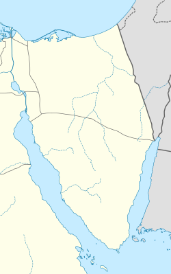
Dahab
Dahab | |
|---|---|
coastal town | |
Overview of Dahab, its beaches and coral reef | |
| Coordinates: 28°29′35″N 34°30′17″E / 28.49306°N 34.50472°E | |
| Country | |
| Governorate | South Sinai |
| Area | |
• Total | 418 sq mi (1,083 km2) |
| Elevation | 69 ft (21 m) |
| Population (2021)[1] | |
• Total | 3,106 |
| • Density | 7.4/sq mi (2.9/km2) |
| Time zone | UTC+2 (EST) |
Dahab (Egyptian Arabic: دهب, IPA: [ˈdæhæb], "gold") is a small town on the southeast coast of the Sinai Peninsula in Egypt, approximately 80 km (50 mi) northeast of Sharm el-Sheikh.
Dahab can be divided into three major parts. Masbat, which includes the Bedouin village of Asalah, in the north; Mashraba, south of Masbat, and Medina in the southwest.[2]
Dahab is mentioned in Deuteronomy as דִ֥י זָהָֽב (dî zāhāḇ), and in the Septuagint translation as Καταχρύσεα. Gesenius exegetes as, “I have no doubt but that it is the same place as that now called Dehab on the western shore of the Ælanitic gulf, where there are many palms.”[3]
Following the Six-Day War of 1967, Sinai was occupied by Israel and Dahab became known as Di-Zahav. The Sinai Peninsula was restored to Egyptian rule under the Egypt–Israel peace treaty in 1982.
Tourism
[edit]
Dahab attracts large numbers of tourists. It is world-renowned for its windsurfing.[4]
Local Bedouin children, sometimes encouraged by their families, come to beach cafes and restaurants to sell items such as woven bracelets to tourists.[5]
Geography
[edit]Landscape
[edit]Dahab contains many mineral deposits, including rutile, zircon, monazite, leucoxene, and gold. Many of these are Neoproterozoic rocks such as schist.[6]
Climate
[edit]Dahab has a hot desert climate (Köppen: BWh)[7] as the rest of Egypt. The weather on summer days is very hot and also quite hot at night. Winter days are warm and nights are mild. Dahab has a very dry climate and rain is rare, even during the winter months. The precipitation peaks in February.[7]
| Climate data for Dahab | |||||||||||||
|---|---|---|---|---|---|---|---|---|---|---|---|---|---|
| Month | Jan | Feb | Mar | Apr | May | Jun | Jul | Aug | Sep | Oct | Nov | Dec | Year |
| Mean daily maximum °C (°F) | 21.0 (69.8) |
22.4 (72.3) |
25.3 (77.5) |
28.7 (83.7) |
32.2 (90.0) |
34.7 (94.5) |
35.5 (95.9) |
35.8 (96.4) |
33.5 (92.3) |
30.5 (86.9) |
26.5 (79.7) |
22.2 (72.0) |
29.0 (84.3) |
| Daily mean °C (°F) | 15.6 (60.1) |
16.7 (62.1) |
19.6 (67.3) |
22.9 (73.2) |
26.1 (79.0) |
29.0 (84.2) |
30.2 (86.4) |
30.4 (86.7) |
28.4 (83.1) |
25.1 (77.2) |
21.1 (70.0) |
16.8 (62.2) |
23.5 (74.3) |
| Mean daily minimum °C (°F) | 10.2 (50.4) |
11.0 (51.8) |
14.0 (57.2) |
17.1 (62.8) |
20.1 (68.2) |
23.4 (74.1) |
24.9 (76.8) |
25.0 (77.0) |
23.4 (74.1) |
19.8 (67.6) |
15.7 (60.3) |
11.5 (52.7) |
18.0 (64.4) |
| Average precipitation mm (inches) | 1 (0.0) |
2 (0.1) |
2 (0.1) |
0 (0) |
0 (0) |
0 (0) |
0 (0) |
0 (0) |
0 (0) |
1 (0.0) |
1 (0.0) |
2 (0.1) |
9 (0.3) |
| Average rainy days | 1 | 1 | 1 | 1 | 1 | 0 | 0 | 0 | 0 | 1 | 1 | 1 | 8 |
| Mean daily sunshine hours | 8 | 9 | 9 | 10 | 11 | 13 | 13 | 12 | 11 | 10 | 9 | 8 | 10 |
| Source 1: Climate-Data.org[7] | |||||||||||||
| Source 2: Weather to Travel for rainy days and sunshine[8] | |||||||||||||
| Jan | Feb | Mar | Apr | May | Jun | Jul | Aug | Sep | Oct | Nov | Dec |
|---|---|---|---|---|---|---|---|---|---|---|---|
| 22 °C (72 °F) | 21 °C (70 °F) | 21 °C (70 °F) | 23 °C (73 °F) | 25 °C (77 °F) | 26 °C (79 °F) | 28 °C (82 °F) | 28 °C (82 °F) | 28 °C (82 °F) | 27 °C (81 °F) | 25 °C (77 °F) | 23 °C (73 °F) |
See also
[edit]References
[edit]- ^ a b c "Dahab (Kism (urban and rural parts), Egypt) - Population Statistics, Charts, Map and Location". citypopulation.de. Retrieved 17 March 2023.
- ^ "Dahab - Red Sea", TripAdvisor.com, retrieved 25 August 2023
- ^ "דִּי זָהָב".
- ^ Boraie, Eihab (2020-06-17). "Why Egypt's Dahab is the perfect Red Sea resort town". CNN. Retrieved 2023-11-03.
- ^ Barbara Bender, ed. (2001). Contested landscapes: movement, exile and place; [World Archaeological Congress ... Cape Town, South Africa]. Oxford [u.a.]: Berg. p. 372. ISBN 978-1-85973-467-4.
- ^ Surour, Adel A.; El-Kammar, Ahmed. M. A.; Arafa, Ebtisam H.; Korany, Hala M. (2021-12-01). "Mineralogy and geochemistry of fine-grained Dahab stream sediments, Southeastern Sinai, Egypt: emphasis on the intergrowths of Fe–Ti oxides". Acta Geochimica. 40 (6): 871–894. doi:10.1007/s11631-021-00475-1. ISSN 2365-7499.
- ^ a b c "Climate: Dahab - Climate graph, Temperature graph, Climate table". climate-data.org. Retrieved 13 August 2013.
- ^ a b "Dahab Climate and Weather Averages, Egypt". Weather to Travel. Archived from the original on 17 November 2018. Retrieved 5 November 2013.
External links
[edit] Dahab travel guide from Wikivoyage


